Wednesday, July 31, 2013

More Rain on the way for the Mid Atlantic

Hello Everyone,
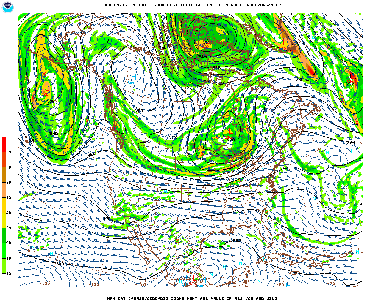
It looks as if a model consensus has hit us supporting a increased chance for higher QPF amounts up and down the Mid Atlantic Coasts. Looking at the current observations and radar, you can distinctively see 3 separate systems, all of which will effect our weather in some way tomorrow.
Models have came together to agree on developing a secondary coastal low with the energy situated on the South Eastern US coast. You can see all three pieces of energy very easy on the NAM 500mb chart. With the approaching cold front to the east. The developing coastal low can easily maneuver up the east side of the trough, and use with the energy associated with the cold front to the west. Were the energy from the cold front and the coastal low interact, will form a thin line of the heaviest convection were the heaviest QPF axis will form. 
Most models agree that this 3 piece system will drop heavy amounts of precipitation. Were the heaviest will drop is not completely known. Lets take a look at what 3 different models are showing. Lets start with the GEM
The 12z GEM came in quite wet for the I-95 corridor and much drier for out viewers outside. The GEM really wants the Secondary Coastal low to gain strength rapidly. Doing so will sap the other pieces of energy and weaken the cold front of their convection and keep the area they move over drier. 
You can easily see the weak cold front over Central NY, Eastern PA, down to Maryland. Also look how the secondary Low centered near North Carolina is strengthening in convection. 
Now the cold front has phased with the Coastal Low an the convection from the Main LP is dissipated. The Coastal Low is throwing heavy DBZ bands back over the area with enhanced moisture feed from the SST. With this solution the I-95 corridor would be the area with the most QPF totals. 
Most of the NAM runs today agree with this situation. Looking at the 18z 12Km NAM, its very similar to the GEM, but it wants to keep the initial cold front and pieces of energy to the north stronger than the GEM. Take a look at the simulated 12Km radar.
This is hour 21. See how the coastal low is still situated in North Carolinia, yet the cold front has reached NJ. The LLJ associated with the cold front has allowed the convection to stay stronger. 
Now the cold front moves more through the area and the coastal low is now throwing back more precipitation. Were the Cold front and coastal low interact on this run ends up being in Eastern PA and Western Jersey  down all the way to Maryland. With that the heaviest QPF axis will extend in that region. The NAM also want s to give heavy QPF amounts to Upstate and Western NY. 
With this solution, the QPF maximum axis would be more west than the GEM
The GFS is the outlier at the moment. It dos not really energize the developing coastal low, and is also weaker with the front. It also displaces the heaviest QPF axis into Maryland then into Connecticut. I don't agree with this output map. The GFS isn't close to the consensus so i must count is as the improbable solution right now.
Looking at the current observations and seeing a increasing in convection blow up to the system to the north and east, and the secondary low to the South, i believe most area in the Mid Atlantic are in for a soaking tomorrow. I think a solution a little less amplified than the GEM is showing is the right way to think right now. Widespread 1.5" plus in the I-95, about .5 -1.00 outside the I-95 with a chance for more precipitation in Western NY and Upstate NY in the Adirondacks.  Check your States tab for Rainfall forecasts and a much shorter individual blog.
Have a great day
Ryan Remondelli


Monday, July 29, 2013

Below Average temperatures ahead, More Rainfall for the Weekend?

Hi all,
After some places picking up over a inch yesterday in precipitation, mostly in interior NJ, it looks as if we will quiet out fro the week ahead. Lets take a quick look at the tropics....

Invest 91-L is spinning north of Puerto Rico at this time. Lots of people are calling for the regeneration of this system. I am not seeing it. Since its dissipation from a closed off Tropical Storm, the Low Level vort associated with ex-Dorian and the Mid-level vort are disjointed. The LLV is displaced well west of the MLC rotation. The convection flare ups associated with the wave, are seen over the MLC, not the LLV which would be needed in order for the convection to wrap around and close off the system.  Taking that into consideration, when Invest 91-L moves more WNW to W, it will move into area with total shear velocity of over 30+ Knots. With out a some what closed LLC stacked upon the MLC, this tropical wave has no chance to regenerate. More information from the ASCAT as the day went on confirming that the mid level trough has become less organize and the satellite cant find a single east wind on the South side of the system. AS the wind shear eats at the Mid level center, the convection will fade and blow away. The remaining convection will be weak so it wont be under the influence of the trough located on the east coast and will drift ever so slowly west toward Cuba, and Florida bringing some rainfall to those areas. Some models eventually have the reaming convection re curve into the Southern US Gulf Coast. But what happens their remains to be seen. Models did a god awful job forecasting this one. But it was another early season Cape-Verde system, which are the most difficult to forecast in terms of intensity.
As you can see from the Water Vapor loop the dry air and shear has ripped 91-L of is highest convection tops and has no high cloud tops near the MLC.

Looking closer to home, the model consensus keeps the area dry for the most part with the exclusion of some high clouds till Thursday. Expect highs in the low to mid 80s with low humidity and normal dew points.

Then on Thursday the Giant Vort Maximum over the Great lakes moves ENE bringing a line of forcing into the area by Friday. This forcing will supply enough upper level divergence to develop convection ahead of this front. Models have yet to come to a consensus on the strength of the Low Level Jet, Shear, and composite indices ahead of the front. With great divergence on these indices the QPF output forecasts differ greatly between models. Id say wait till Wednesday for a consensus with the Hi-Res Models to pin down the heaviest QPF axis and timing with this. But one thing is for sure, after the front moves through a deeper trough will develop into the eastern US, and once again, temperatures will be cool. With the telleconnections agreeing on a cooler pattern (neutral AO, Neutral NAO, very positive PNA, with Negative EPO) with the MJO composite forecast, and the EURO weeklies,  The August CFS V2 agrees with my thoughts on a cooler august than average. The CFS has done a fantastic Job this summer, and is well supported by telleconnections and the MJO composite forecasts I mentioned before.
Hope everyone has a great week!
Ryan Remondelli

Saturday, July 27, 2013

Models Trending to lighter Rainfall

Hi all,
Just a short quick update.
After a beautiful day for the most part in New Jersey today, it looks like the weekend is headed for a short 180 spin. Model Spreads have been rather interesting over today as it seems that the bulk of the QPF axis will be to the west and to the east of our area.

Rain will move into the area tonight as a cold front approaches from the west, and a weak Low Pressure moves east of the area following the flow around the trough. Yesterday models had the cold front pushing east on a slower approach, allowing the weak coastal low to move up along the trough and over the area, enhancing rainfall rates and QPF totals. But model guidance today have confined on a consensus that the Front will approach at a accelerated pace, pushing the weak coastal low OTS, and force it to be a none factor for our area tomorrow except for some ruff surf along the beaches.
As seen yesterday, guidance has also continued to show the cold front weakening as it pushes east. Most model spit out the heaviest DBZ bands over central and eastern Pennsylvania, before having the storms rapidly weaken due to the incredibly stable and marine layer infused atmosphere in New Jersey. Most models show a total QPF accumulation the next 48 hours between .25 and 1 inch. Western New Jersey will likely see the heaviest banding and the best chance for higher QPF amounts due to less of a marine influence. Once the convection reaches the coastal plain, it will die out rapidly as seen many times this year. The GFS is the most aggressive in terms of QPF output in New Jersey tomorrow, and i would call it the more extreme solution, while the GEM and NAM have between .25-.5 inches of total accumulation. I'm siding with the GEM and NAM with the lower targeted QPF total with this one. Looking at the current radar and Mesocale , the bulk of the heaviest convection has it axis over eastern PA, exactly were the NAM and GEM have it at this time. Some places may over preform if they get stuck in a elevated convection feed for a long duration, some places, especially along the coast have the possibility to stay dry.

Looking forward into the longer term, most modes still want to bring a deep mean trough into the Eastern United states. There is quite the model consensus with this solution also. The ECMWF, GFS, and GEM all agree that this pattern change will stay to at least the first week or two of august. The telleconnections( - AO through the first week of august, + to neutral PNA, and a neutral to -NAO) and MJO support this type of pattern. Model guidance has actually trended stronger  and deeper with the trough it self. With this in place, the first two weeks of august  and the last week or two of July could be just near normal to below average. After mid August model guidance separates into again wanting to rebuild the Western Atlantic Ridge into the ara, or keep a more zonal cooler pattern.
Stay Dry tomorrow, and get ready for a nice cool Monday!
I will have a longer update tomorrow on the week ahead and longer range going forward.
Have a good night!
Ryan Remondelli

Friday, July 26, 2013

Fantastic Start to the Weekend

Good Morning Everyone,

Its looks as if Model Guidance over night has trended for a "nicer" Friday. Most models have increased Max temperatures for the day today, and for coastal sections, have weakened the sea breeze forecast.
Lets start,
 The LP that effected our area yesterday leaving us with a autumn like feel, is leaving our area to the north quicker than foretasted. This allowed the heaviest cloud cover axis to be significantly further east than anticipated at this time in the morning. Also the earlier departure will allow the  north east winds to shift out from the east to a due south flow earlier. Thus it will allow the 850 temperatures to move into the 12+ degree Celsius range, with more day time heating. All of this means, warmer Max temperatures today, with most places away from the coast in interior NJ seeing low 80s today. This while temperatures along the beaches stay into the mid to high 70s, with a lighter sea breeze under 5-6 knots( a heavy sea breeze of 8+ knots along with low 70s was the model agreement yesterday) marks a improvement for the start of another busy weekend here dawn at the shore.
Saturday looks to be the best day here in NJ this weekend. With a warm and some what humid Southwesterly flow with 14-16 degree Celsius 850s above, will allow almost every one to get into the 80s in the area. Not much to talk about for tomorrow.

Sunday itself will get more interesting as another cold front will start approaching from the west. There is a few possible solutions i want to go over.

One of my favorite model the GEM, wants to move the cold front int Pennsylvania, but then weakens the front and transfers the southern end of the cold front's energy to a coastal low developing near South Carolina. Due to the LP being ahead of the negatively tilted 500mb trough it has a chance to move offshore, and pull in and deepen over warm SST.
Here is the GEM hour 66. You can see the Main LP voracity over the Great Lakes, and the negatively tilted trough over the east. Its axis is from Indianapolis to Jacksonville Florida. With that tilt you can see the LP being able to effect NJ( the dark shade.) You can also see a enhanced LLJ on the GEM in the 500mb. The line of weak energy along the cold front will help enhance rainfall rates in conjunction with the counterclockwise flow pulling moisture off the ocean. It almost looks as it is trying to form a CCB complex around the low level circulation. 

You can easy see how the moisture feed off the warm SST effects the heaviest precipitation axis.

Now lets take look at the other end of the guidance. The latest GFS ha trended a bit to the rest of the model field but still dose not show a developing coastal low. It has the cold front weaken as the rest of guidance. It does transfer some energy to a 1013mb low, but that low does not develop, and its precipitation shield weakens before moving offshore. 

What could be causing the GFS to be so different? Well lets look at the 500mb map differences for the same hour.
The Main low pressure near the Great Lakes is lot stronger aloft than on the GEM. This is due mostly due to the fact of the GEM intention of phasing part of the energy from the ULL over the lakes. With out the phase and any LLJ help from the trough or the ULL, the GFS coastal low, is almost non existent, and cant deepen. The Trough over the east is less negatively tilted not giving the Circulation enough time or power to grab the SST off the Atlantic and strengthen.
Their is lots to work out for Sunday and i hope we can get a model consensus on track, strength, and QPF amounts by Saturday morning, but by how the models have preformed so far in July, i can only hope.
Have a Great Weekend
Ryan Remondelli