Friday, August 23, 2013

Possible MCS Event for the 28-29th

Sorry for the lack of posts,
Weather has been lacking in excitement.
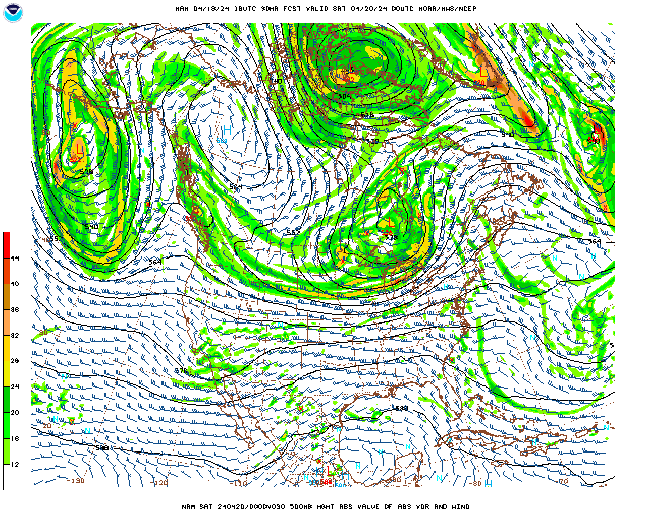
Anyay, it looks as if we could could be in for a possible MCS event for the 28-29th. MCS stands for Mesoscale Convective System, and is basically a large concentrated squall line that travels extended distances. And it looks as if we have a good set up for one to form. The GFS and the EURO are at much different solutions right now. The GFS want this MCS event to be a more mid Atlantic event, actually missing us with the precip to the south, while the EURO Is more of a hit for the area. The Difference in the solutions is really at the 500mb level. BY that time it looks as if their will be a +EPO, and a Negative PNA. Meaning that their will be a ridge in the pacific telleconnecting to a trough on the west coast, connecting to a ridge in the central part of the country, and a trough in the east. Thats how telleconnections work, its all physical reactions.


But at the 500mb the EURO and GFS are quite different were they want to set up the ridging in the middle of the country.
The GFS want to develop a much more_PNA thus a sharper trough into the west coast allowing the center of the ridge to be further west. With the sharper trough in the west, the reaction in the east coast to the farther west ridge is a much sharper and south trough in the east. 


This allows for the energy and precipitation associated with the ULL to dive much further south missing the area.


Meanwhile the EURO and its better physics drive, is showing a less amplified -PNA trough in the west coast, allowing a more east based center of the ridging. The only allows for a weaker and more east (offshore, more zonal for our area) based trough , keeping the ULL more to the north, thus the MCS convection to the north also hitting the area.


This more northern track puts us in the line of fire

The GEM also agrees with the EURO in terms of set up. But has a more amplified west based trough in the east allowing for the MCS convection to come right through the mid Atlantic
The GEM is the moderate here in the situation.

Im betting on a track between the Euro and the GEM and their more advanced physics drives with this one. But we will see in the coming days how the models advance with the pattern.
Have a good one. 

Wednesday, August 14, 2013

Cooler weather, tropics heating up

Hi all,
With the trough nicely situated in the east for the next couple days, a high pressure sitting to our west, and cool 850s above with clear skies, i think we have a chance for some record lows tonight. Models have most people on the coastal plain bottoming out in the low 60s, due to marine layer influence, but people 50-60 miles inland that have a more Northerly flow from the HP to the west, will see temperatures reaching into the 50s, and maybe a outside chance for a high 40 degree reading, especially in the tallest mountainous areas.
A look into the tropics sees invest 92-L in the Caribbean, and invest 93 in the Atlantic. Both are given a high probability by the NHC in formation.
 I believe invest 92-l is a greater threat to the immediate US coast at this time, given most ensemble models forecasting it to be picked up by a approaching frontal boundary to the north and directed into the Southern US coast. Intensity models are varying greatly with 92-L given the exact formation and position of the stacked LLC, and MLC is not fully observed and or known yet, giving forecast models a hard time forecasting how much interaction with the Yucatan Peninsula and how much time over the warm GOM SST it will have. If 92-l takes a more slower and westward track with more interaction with the Yucatan, it could be at a greater risk with increased wind shear and of course land interaction disrupting the circulations developmental ability and sustainment. But if it takes a more  expedited and easterly track, it has a greater chance to develop over the warm SST and a more favorable environment.
Invest 93 is a little less exciting. Given the foretasted movement to the NW, it looks as if 93 will eventually develop, but will likely be held to lower strength and intensity over the next couple days due to cooler SST, and the increased presence of the Saharan Dry air still embedded in the Atlantic.
I guess it is a race to the next name storm....
Have a great day!
Ryan Remondelli

Monday, August 12, 2013

Heavy Rain on Way tonight. Possible Severe Weather too.

Hello all,
Quick update. Looks like we could be in for a possible severe weather event tonight. Even if severe weather does not effect your area,  you will see very heavy rain.
With the convection approaching from the west of the area, it has become clear that their will be 35+ km of shear available for the super structure of the thunderstorms in some parts of the area. This will allow the thunderstorms to maintain their strength as they move into our areas. Severe weather potential mostly likely further east in the coverage area as the foretasted shear is greatest their. Without high instability, and thermodynamics in the west coverage area, severe potential is less likely and some what more limited. But in the eastern coverage areas (Eastern NY west, Central PA west) with higher thermodynamics and much higher bulk Shear Values, the chance is greater. Expect between .75 and 2 inches of rain with heavier in isolated spots with trailing convection lines. Rain should move in tonight and last into tomorrow morning before we cool down for the reaming week. Their is a coastal storm chance during the week, as models have hinted that a low Pressure will form in the GOM and ride the ridge axis and effect our area. That system needs to be ironed out later.
Stay safe tonight and tomorrow.
Ryan Remondelli

Wednesday, August 7, 2013

A quick update,
Rain continues tonight and into Friday as instability hangs around from the approachng trough. After a quick chance for mid to upper 80s this weekend with warmer 850's and a SW flow, most models show a reloaded trough moving back east that could be stronger and more vertically oriented, or more zonal than this past one, either way keeping us below average for most of next week. As i mentioned, i  think the question is how  below average we will get. Models agree on moving in a trough, but their is a discrepancy on how vertically oriented and strong the trough itself will get. taking a look at the GFS and GEM discrepancy at the 500mb heights. Both show a strong ULL over Canada between 136 and 150 hours,
The GEM has a 594 DM high popping a strong + PNA ridge in the west. You can also notice the HP center is further west itself. This allows the Upper Level Vort over Canada to react and form a sharper and stronger vort with tighter pressure gradients over the Eastern US and Build a strong 1023mb high on the back side of the trough
 
With the tight trough over the Eastern US with a strong Vort Max over Canada it allows even cooler air to filter in behind the departing ULL bringing much below average 850's and in turn temperatures.
 
The GFS on the other hand has a much weaker Hp is the SW that is displaced further east due to the GFS's accelerated movement of the ULL. With out the HP being further west and in a more stronger and dominating position, it is unable to form a more vertically oriented Positive ridge in the west, therefore not allowing the ULL to dive further south and enhance the trough, making the pattern in the Eastern US more zonal than the GEM.
 
At 150 hours you can easy see the difference between the GFS and GEM, the GFS has the ULL much father to the east than the GEM, and a almost complete zonal pattern with little vertical tilt to the Jet stream. this allows more seasonable temperatures to stay in the area with a west wind rather than a cool NW or N wind  and allowing the bulk of the cooler weather to the west.
 

Their has been a trend to a weaker trough in the east in this time period over the last day or two. If this trend continues we will not see much below average temps, but if the global guidance holds suite we could be in for a even more pronounced cool down. We will see how models trened the next couple days.

Monday, August 5, 2013

Cooler Start to the week, then rain for the area.

Hello all,
With a situated mean trough over the north east brought in by the heavy rain and a strong front on Friday and Saturday for most parts of the coverage area, we were lucky to see a sunny and cool "September" day for most of the area. Temperature departed for our areas are between 3 and 7 degrees below normal. This excessive drop in temperatures is not that uncommon in the area, but is rare enough to be mentioned.
The much cooler than average temperatures over the area is mostly due to the fact that we have a -AO hence a strong polar vortex to the north. This flip from a strong + AO to a negative AO in late July in conjunction to very good blocking with a -NAO has allowed a mean trough to build into the area and stay rather stagnant with multiple reloading phases thus far.
Here you can see the strong positive heights in northern Canada and into Greenland, mostly something you would see in a strong cool pattern in winter. But with position of the trough axis onver the area, the Hp with its clockwise flow will have winds out of the cooler Canadian 850s, and will force us to stay below average again for most parts. Most models have the trough reloading once again mid week bringing a front through increasing instability over the Wednesday to Thursday time period. this will allow a good inch to 2 inches of QPF to drop in most areas. But after that front moves through in the Friday, through Saturday time frame some model are hinting at the chance we could see one or 2 pop up 90 degree days, ambit with decent humidity. We will have warm 850s with a favorable SW flow due to the advancing trough and HP to the east and a slowly approaching front to the west. With the Southwest flow, the 850 temperatures will rise drastically improving the daytime heating effect. Here is the GFS for Friday clearly showing the rebuilding trough to the west with the above average temperatures ahead of it in the east.
The GEM agrees with this scenario. 
Most models agree that the Warmest cities and areas will have the chance to hit 90, but most places will just stay 2-3 degrees above normal. yet again, Most models rebuild the trough into the east coast, but in the longer range telecommunications and the MJO forecast have put some light into the fact the Bermuda High might have a chance to retrograde back east as the heights in Canada and  the very strong ridging in the southern US might weaken. Models are mostly split on rebuilding the heat, but it could be a likely scenario for the very end of august and into early September. A trough just to the west of the area with a South flow from the Bermuda high to the east may not be the greatest setup in the heat of hurricane season. But for now, enjoy the fall weather, and stay dry.
Ill be back mid week on a update on how the tropics might heat up quickly, how the pattern developing might put the east coast at risk, and maybe a quick thought on what we may be in for next winter...or i might wait for that. Lol.
Have a great week.
Ryan Remondelli


Wednesday, July 31, 2013

More Rain on the way for the Mid Atlantic

Hello Everyone,
It looks as if a model consensus has hit us supporting a increased chance for higher QPF amounts up and down the Mid Atlantic Coasts. Looking at the current observations and radar, you can distinctively see 3 separate systems, all of which will effect our weather in some way tomorrow.
Models have came together to agree on developing a secondary coastal low with the energy situated on the South Eastern US coast. You can see all three pieces of energy very easy on the NAM 500mb chart. With the approaching cold front to the east. The developing coastal low can easily maneuver up the east side of the trough, and use with the energy associated with the cold front to the west. Were the energy from the cold front and the coastal low interact, will form a thin line of the heaviest convection were the heaviest QPF axis will form. 
Most models agree that this 3 piece system will drop heavy amounts of precipitation. Were the heaviest will drop is not completely known. Lets take a look at what 3 different models are showing. Lets start with the GEM
The 12z GEM came in quite wet for the I-95 corridor and much drier for out viewers outside. The GEM really wants the Secondary Coastal low to gain strength rapidly. Doing so will sap the other pieces of energy and weaken the cold front of their convection and keep the area they move over drier. 
You can easily see the weak cold front over Central NY, Eastern PA, down to Maryland. Also look how the secondary Low centered near North Carolina is strengthening in convection. 
Now the cold front has phased with the Coastal Low an the convection from the Main LP is dissipated. The Coastal Low is throwing heavy DBZ bands back over the area with enhanced moisture feed from the SST. With this solution the I-95 corridor would be the area with the most QPF totals. 
Most of the NAM runs today agree with this situation. Looking at the 18z 12Km NAM, its very similar to the GEM, but it wants to keep the initial cold front and pieces of energy to the north stronger than the GEM. Take a look at the simulated 12Km radar.
This is hour 21. See how the coastal low is still situated in North Carolinia, yet the cold front has reached NJ. The LLJ associated with the cold front has allowed the convection to stay stronger. 
Now the cold front moves more through the area and the coastal low is now throwing back more precipitation. Were the Cold front and coastal low interact on this run ends up being in Eastern PA and Western Jersey  down all the way to Maryland. With that the heaviest QPF axis will extend in that region. The NAM also want s to give heavy QPF amounts to Upstate and Western NY. 
With this solution, the QPF maximum axis would be more west than the GEM
The GFS is the outlier at the moment. It dos not really energize the developing coastal low, and is also weaker with the front. It also displaces the heaviest QPF axis into Maryland then into Connecticut. I don't agree with this output map. The GFS isn't close to the consensus so i must count is as the improbable solution right now.
Looking at the current observations and seeing a increasing in convection blow up to the system to the north and east, and the secondary low to the South, i believe most area in the Mid Atlantic are in for a soaking tomorrow. I think a solution a little less amplified than the GEM is showing is the right way to think right now. Widespread 1.5" plus in the I-95, about .5 -1.00 outside the I-95 with a chance for more precipitation in Western NY and Upstate NY in the Adirondacks.  Check your States tab for Rainfall forecasts and a much shorter individual blog.
Have a great day
Ryan Remondelli


Monday, July 29, 2013

Below Average temperatures ahead, More Rainfall for the Weekend?

Hi all,
After some places picking up over a inch yesterday in precipitation, mostly in interior NJ, it looks as if we will quiet out fro the week ahead. Lets take a quick look at the tropics....

Invest 91-L is spinning north of Puerto Rico at this time. Lots of people are calling for the regeneration of this system. I am not seeing it. Since its dissipation from a closed off Tropical Storm, the Low Level vort associated with ex-Dorian and the Mid-level vort are disjointed. The LLV is displaced well west of the MLC rotation. The convection flare ups associated with the wave, are seen over the MLC, not the LLV which would be needed in order for the convection to wrap around and close off the system.  Taking that into consideration, when Invest 91-L moves more WNW to W, it will move into area with total shear velocity of over 30+ Knots. With out a some what closed LLC stacked upon the MLC, this tropical wave has no chance to regenerate. More information from the ASCAT as the day went on confirming that the mid level trough has become less organize and the satellite cant find a single east wind on the South side of the system. AS the wind shear eats at the Mid level center, the convection will fade and blow away. The remaining convection will be weak so it wont be under the influence of the trough located on the east coast and will drift ever so slowly west toward Cuba, and Florida bringing some rainfall to those areas. Some models eventually have the reaming convection re curve into the Southern US Gulf Coast. But what happens their remains to be seen. Models did a god awful job forecasting this one. But it was another early season Cape-Verde system, which are the most difficult to forecast in terms of intensity.
As you can see from the Water Vapor loop the dry air and shear has ripped 91-L of is highest convection tops and has no high cloud tops near the MLC.

Looking closer to home, the model consensus keeps the area dry for the most part with the exclusion of some high clouds till Thursday. Expect highs in the low to mid 80s with low humidity and normal dew points.

Then on Thursday the Giant Vort Maximum over the Great lakes moves ENE bringing a line of forcing into the area by Friday. This forcing will supply enough upper level divergence to develop convection ahead of this front. Models have yet to come to a consensus on the strength of the Low Level Jet, Shear, and composite indices ahead of the front. With great divergence on these indices the QPF output forecasts differ greatly between models. Id say wait till Wednesday for a consensus with the Hi-Res Models to pin down the heaviest QPF axis and timing with this. But one thing is for sure, after the front moves through a deeper trough will develop into the eastern US, and once again, temperatures will be cool. With the telleconnections agreeing on a cooler pattern (neutral AO, Neutral NAO, very positive PNA, with Negative EPO) with the MJO composite forecast, and the EURO weeklies,  The August CFS V2 agrees with my thoughts on a cooler august than average. The CFS has done a fantastic Job this summer, and is well supported by telleconnections and the MJO composite forecasts I mentioned before.
Hope everyone has a great week!
Ryan Remondelli

Saturday, July 27, 2013

Models Trending to lighter Rainfall

Hi all,
Just a short quick update.
After a beautiful day for the most part in New Jersey today, it looks like the weekend is headed for a short 180 spin. Model Spreads have been rather interesting over today as it seems that the bulk of the QPF axis will be to the west and to the east of our area.

Rain will move into the area tonight as a cold front approaches from the west, and a weak Low Pressure moves east of the area following the flow around the trough. Yesterday models had the cold front pushing east on a slower approach, allowing the weak coastal low to move up along the trough and over the area, enhancing rainfall rates and QPF totals. But model guidance today have confined on a consensus that the Front will approach at a accelerated pace, pushing the weak coastal low OTS, and force it to be a none factor for our area tomorrow except for some ruff surf along the beaches.
As seen yesterday, guidance has also continued to show the cold front weakening as it pushes east. Most model spit out the heaviest DBZ bands over central and eastern Pennsylvania, before having the storms rapidly weaken due to the incredibly stable and marine layer infused atmosphere in New Jersey. Most models show a total QPF accumulation the next 48 hours between .25 and 1 inch. Western New Jersey will likely see the heaviest banding and the best chance for higher QPF amounts due to less of a marine influence. Once the convection reaches the coastal plain, it will die out rapidly as seen many times this year. The GFS is the most aggressive in terms of QPF output in New Jersey tomorrow, and i would call it the more extreme solution, while the GEM and NAM have between .25-.5 inches of total accumulation. I'm siding with the GEM and NAM with the lower targeted QPF total with this one. Looking at the current radar and Mesocale , the bulk of the heaviest convection has it axis over eastern PA, exactly were the NAM and GEM have it at this time. Some places may over preform if they get stuck in a elevated convection feed for a long duration, some places, especially along the coast have the possibility to stay dry.

Looking forward into the longer term, most modes still want to bring a deep mean trough into the Eastern United states. There is quite the model consensus with this solution also. The ECMWF, GFS, and GEM all agree that this pattern change will stay to at least the first week or two of august. The telleconnections( - AO through the first week of august, + to neutral PNA, and a neutral to -NAO) and MJO support this type of pattern. Model guidance has actually trended stronger  and deeper with the trough it self. With this in place, the first two weeks of august  and the last week or two of July could be just near normal to below average. After mid August model guidance separates into again wanting to rebuild the Western Atlantic Ridge into the ara, or keep a more zonal cooler pattern.
Stay Dry tomorrow, and get ready for a nice cool Monday!
I will have a longer update tomorrow on the week ahead and longer range going forward.
Have a good night!
Ryan Remondelli

Friday, July 26, 2013

Fantastic Start to the Weekend

Good Morning Everyone,

Its looks as if Model Guidance over night has trended for a "nicer" Friday. Most models have increased Max temperatures for the day today, and for coastal sections, have weakened the sea breeze forecast.
Lets start,
 The LP that effected our area yesterday leaving us with a autumn like feel, is leaving our area to the north quicker than foretasted. This allowed the heaviest cloud cover axis to be significantly further east than anticipated at this time in the morning. Also the earlier departure will allow the  north east winds to shift out from the east to a due south flow earlier. Thus it will allow the 850 temperatures to move into the 12+ degree Celsius range, with more day time heating. All of this means, warmer Max temperatures today, with most places away from the coast in interior NJ seeing low 80s today. This while temperatures along the beaches stay into the mid to high 70s, with a lighter sea breeze under 5-6 knots( a heavy sea breeze of 8+ knots along with low 70s was the model agreement yesterday) marks a improvement for the start of another busy weekend here dawn at the shore.
Saturday looks to be the best day here in NJ this weekend. With a warm and some what humid Southwesterly flow with 14-16 degree Celsius 850s above, will allow almost every one to get into the 80s in the area. Not much to talk about for tomorrow.

Sunday itself will get more interesting as another cold front will start approaching from the west. There is a few possible solutions i want to go over.

One of my favorite model the GEM, wants to move the cold front int Pennsylvania, but then weakens the front and transfers the southern end of the cold front's energy to a coastal low developing near South Carolina. Due to the LP being ahead of the negatively tilted 500mb trough it has a chance to move offshore, and pull in and deepen over warm SST.
Here is the GEM hour 66. You can see the Main LP voracity over the Great Lakes, and the negatively tilted trough over the east. Its axis is from Indianapolis to Jacksonville Florida. With that tilt you can see the LP being able to effect NJ( the dark shade.) You can also see a enhanced LLJ on the GEM in the 500mb. The line of weak energy along the cold front will help enhance rainfall rates in conjunction with the counterclockwise flow pulling moisture off the ocean. It almost looks as it is trying to form a CCB complex around the low level circulation. 

You can easy see how the moisture feed off the warm SST effects the heaviest precipitation axis.

Now lets take look at the other end of the guidance. The latest GFS ha trended a bit to the rest of the model field but still dose not show a developing coastal low. It has the cold front weaken as the rest of guidance. It does transfer some energy to a 1013mb low, but that low does not develop, and its precipitation shield weakens before moving offshore. 

What could be causing the GFS to be so different? Well lets look at the 500mb map differences for the same hour.
The Main low pressure near the Great Lakes is lot stronger aloft than on the GEM. This is due mostly due to the fact of the GEM intention of phasing part of the energy from the ULL over the lakes. With out the phase and any LLJ help from the trough or the ULL, the GFS coastal low, is almost non existent, and cant deepen. The Trough over the east is less negatively tilted not giving the Circulation enough time or power to grab the SST off the Atlantic and strengthen.
Their is lots to work out for Sunday and i hope we can get a model consensus on track, strength, and QPF amounts by Saturday morning, but by how the models have preformed so far in July, i can only hope.
Have a Great Weekend
Ryan Remondelli